In my previous post, I began showing how I taught a Bible study using the Slide Show feature of Accordance. This feature lets you present any workspace with tabs as a series of “slides,” with each tab constituting one “slide.” The only caveat is that all the tabs have to be in a single zone, so you may have to drag one into another before you use this feature.
In setting up the workspace I would present as a slide show, I began by assembling the various passages I would be reading. My main passage was the story of Elijah’s showdown with the prophets of Baal in 1 Kings 18, but I also wanted to read a few related passages. I set each passage up in its own tab so I could quickly turn to each one without scrolling or navigating. Again, see my previous post for details on how to do that.
Next I wanted to add some visuals: a map showing the location of Mount Carmel (the setting of this story), photos of the location, images of Baal, etc.
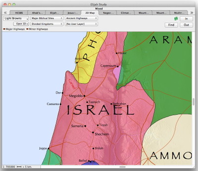
To get the map, I simply selected the word “Carmel” in my main passage and clicked the Map button on the Resource palette. A map opened with Mount Carmel highlighted. Because this story took place during the period of the Divided Kingdom, I chose to overlay the Divided Kingdoms region layer on my map.
Now, here’s where I used a little power-user trick. Because I had searched for Mount Carmel, the name Carmel was highlighted on my map in red. When I added the Divided Kingdoms region layer, the kingdom of Israel was shaded pink, and the combination made the Carmel label difficult to read. So I decided to change the red text to black.
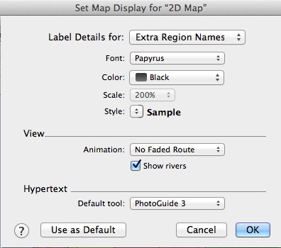
To do that, I simply chose Set Map Display from the Display menu. In the dialog that appeared, I chose Extra Region Names from the main pop-up menu, then changed the Color pop-up from Red to Black.
By the way, the Extra Site Names and Extra Region Names in the main pop-up refer to site and region labels which have been added to the map as the result of a search. They are “extra” in the sense that they appear on the map regardless of whether or not they are actually included in the currently displayed map layers. Accordance gives you the ability to customize those extra labels independent of other map elements.
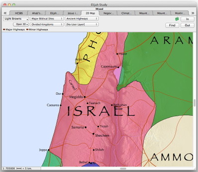
When I clicked OK to close the Map Display settings dialog, my map now looked like this:
During the course of the Bible study, while I was presenting the map, I realized that I wanted to remove the Divided Kingdoms region layer so people could better focus on the topography. If I had anticipated that need, I could have set up a second map tab with a different set of layers and simply switched to it. Because I hadn’t done that ahead of time, I had to exit Slide Show mode in the middle of the Bible study, tweak the map to look the way I wanted, and then enter Slide Show mode again. Fortunately, exiting Slide Show mode is as easy as hitting the escape key, and entering it again merely requires choosing Slide Show from the Window menu. The entire process only took a few seconds.
If you use the Slide Show feature a lot, you should also learn the keyboard shortcut command-option-S, which will toggle the Slide Show on and off.
In my next post, I’ll demonstrate how I gathered the images I wanted to present in my slide show.


